LAEP straddles two LPAs and two NCAs:

  • The Broads
  • South Norfolk Council
  • NCA 80: The Broads
  • NCA 83: South Norfolk and High Suffolk Claylands

LAEP is adjacent to seven LPAs and six NCAs:
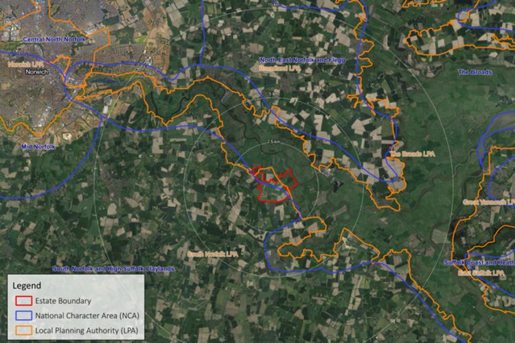
  • Breckland District Council
  • Broadland District Council
  • East Suffolk Council
  • Great Yarmouth Borough Council
  • Mid-Suffolk District Council
  • North Norfolk District Council
  • Norwich City Council
  • NCA 78: Central North Norfolk
  • NCA 79: North East Norfolk and Flegg
  • NCA 82: Suffolk Coast and Heaths
  • NCA 84: Mid Norfolk
  • NCA 85: The Brecks
  • NCA 86: South Suffolk and North Essex Claylands
LAEP Estate Boundaries


Designated a National Priority Focus Area by Natural England, the Langley Abbey Estate is strategically located to provide significant habitat connectivity and maximise nature recovery across the Broads and South Norfolk.

Located within an Environmentally Sensitive Area, a Biodiversity Enhancement Area, and a Sub-Regional Green Infrastructure Corridor, LAEP lies amongst a raft of other nationally and internationally designated sites, including:

Special Area of Conservation (SAC)

  • The Broads

Special Protection Area (SPA)

  • Breydon Water
  • Broadland

Ramsar Site

  • Breydon Water
  • Broadland

National Nature Reserve (NNR)

  • Mid-Yare

Site of Special Scientific Interest (SSSI)

  • Cantley Marshes
  • Duncan’s Marsh, Claxton
  • Hardley Flood
  • Limpenhoe Meadows
  • Poplar Farm Meadows, Langley
  • Yare Broads and Marshes

Important Bird Area (IBA)

  • Breydon Water
  • Broadland

Important Invertebrate Area (IIA)

  • The Broads

Important Plant Area (IPA)

  • The Broads

County Wildlife Site (CWS)

  • Duncan’s Marsh
  • Hazelmere Hole
  • The Thicks

Ancient Woodland Inventory

  • Buckenham Wood
  • Hazelmere Hole
  • Strumpshaw Wood
  • The Thicks


LAEP lies entirely within Natural England’s Habitat Network, spanning all four zones:
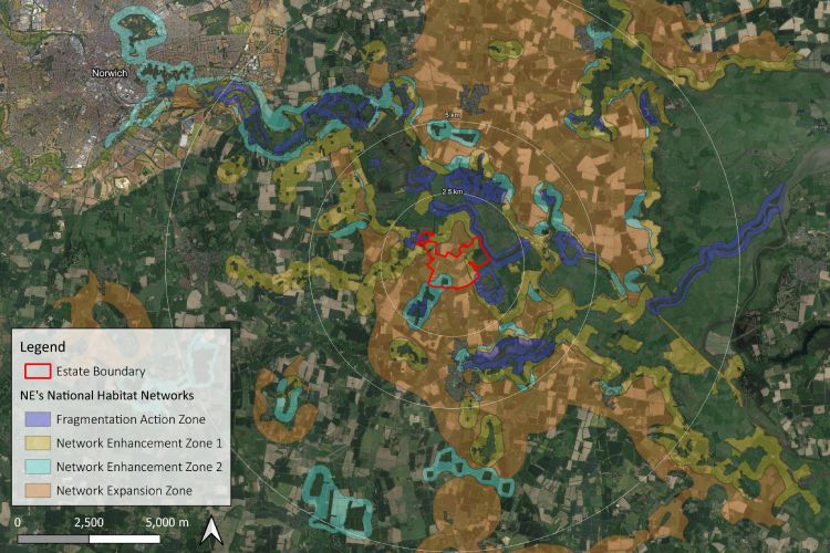
  • Fragmentation Action Zone: Land that connects existing patches of primary habitats which are currently highly fragmented and where fragmentation could be reduced by habitat creation.
  • Network Enhancement Zone 1: Land within close proximity to existing habitat components that are more likely to be suitable for habitat re-creation for the particular habitat.
  • Network Enhancement Zone 2: Land within close proximity to existing habitat components that are unlikely to be suitable for habitat re-creation but where other types of habitats may be created.
  • Network Expansion Zone: Land within relatively close proximity to Network Enhancement Zones 1 & 2 that are more likely to be suitable for habitat creation and locations for connecting and linking up nature networks across a landscape.
Estate NE national habitat networks